東北地理所發(fā)布30米分辨率中國濕地空間分布數(shù)據(jù)集
濕地是“山水林田湖草”生命共同體的重要組成部分,濕地的保護(hù)與管理對于“美麗中國”建設(shè)至關(guān)重要。20世紀(jì)50年代以來,受到氣候變化和人類活動的雙重脅迫,中國濕地面積大幅減少,空間分布范圍明顯萎縮。高精度的濕地空間分布信息是國家濕地保護(hù)與管理決策支持和濕地科學(xué)研究的重大科技需求。
東北地理所王宗明研究團(tuán)隊(duì)近年來在濕地遙感研究領(lǐng)域取得一系列進(jìn)展,主要包括:(1)研發(fā)了高精度國家尺度濕地分布數(shù)據(jù)集CAS_Wetlands、紅樹林動態(tài)數(shù)據(jù)集CAS_Mangroves、互花米草入侵?jǐn)?shù)據(jù)集CAS S. alterniflora、濱海養(yǎng)殖池?cái)U(kuò)張數(shù)據(jù)集CAS_Coastal Aquaculture;(2)基于遙感大數(shù)據(jù),解析了我國濕地面臨的主要威脅,闡明了我國濕地?fù)p失與恢復(fù)的時空特征;(3)構(gòu)建濕地水禽棲息地適宜性評價模型、濕地恢復(fù)空間決策支持模型,建立濕地保護(hù)工程成效遙感評估指標(biāo)體系和評估方法。相關(guān)研究成果發(fā)表于ISPRS Journal of Photogrammetry and Remote Sensing、Science of the Total Environment、Journal of Cleaner Production、International Journal of Applied Earth Observation and Geoinformation、Land Degradation and Development、Remote Sensing、Sensors、Biogeosciences、Journal of Environmental Management、Ecological Engineering等國際重要期刊,并被新華網(wǎng)、中國日報(bào)、央視網(wǎng)、中國科學(xué)報(bào)、科學(xué)網(wǎng)、新浪網(wǎng)、網(wǎng)易、搜狐網(wǎng)等媒體廣泛報(bào)道。這些研究由東北地理所王宗明、毛德華、賈明明、任春穎、宋開山、姜明,東北地理所海外特聘研究員美國印第安納大學(xué)李林、美國羅德島大學(xué)王野喬、美國亞利桑那州立大學(xué)鄔建國,中科院空天信息研究院吳炳方、曾源,中國科學(xué)院國家天文臺張淵智,武漢大學(xué)王超等共同完成。
近期,王宗明研究團(tuán)隊(duì)生產(chǎn)的30米分辨率中國濕地空間分布數(shù)據(jù)集(2015年)在國家地球系統(tǒng)科學(xué)數(shù)據(jù)中心、國家地球系統(tǒng)科學(xué)數(shù)據(jù)中心黑土與濕地分中心、東北地理所科學(xué)數(shù)據(jù)中心公開發(fā)布,免費(fèi)共享,注冊后即可下載。研究團(tuán)隊(duì)采用集成面向?qū)ο蠓椒ㄅc多層決策樹的濕地分類技術(shù)(HOHC),進(jìn)行國家尺度濕地分類,最終獲得2015年中國沼澤濕地、紅樹林、互花米草、濱海養(yǎng)殖池的空間分布數(shù)據(jù)集,總體分類精度在92%以上。該數(shù)據(jù)集可以作為國家落實(shí)聯(lián)合國可持續(xù)發(fā)展目標(biāo)SDGs進(jìn)展?fàn)顩r評估的重要基礎(chǔ),為國家《國際濕地公約》具體履約行動提供關(guān)鍵數(shù)據(jù)支撐,也可為我國濕地生態(tài)系統(tǒng)有效管理與保護(hù)、外來入侵物種防治、濕地恢復(fù)空間決策支持提供科學(xué)依據(jù)。
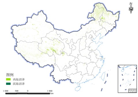
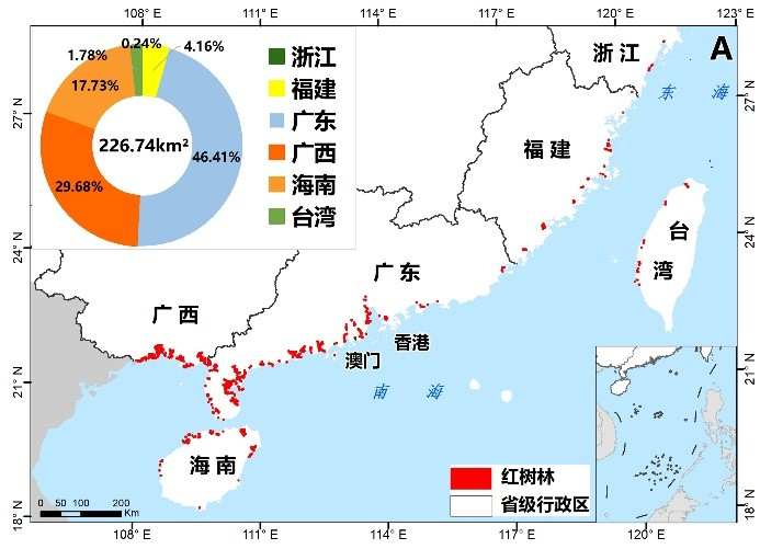
中國沼澤濕地空間分布(2015年) 中國紅樹林空間分布(2015年)
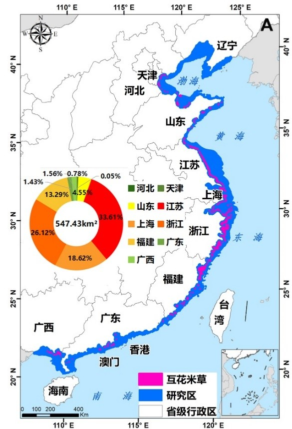
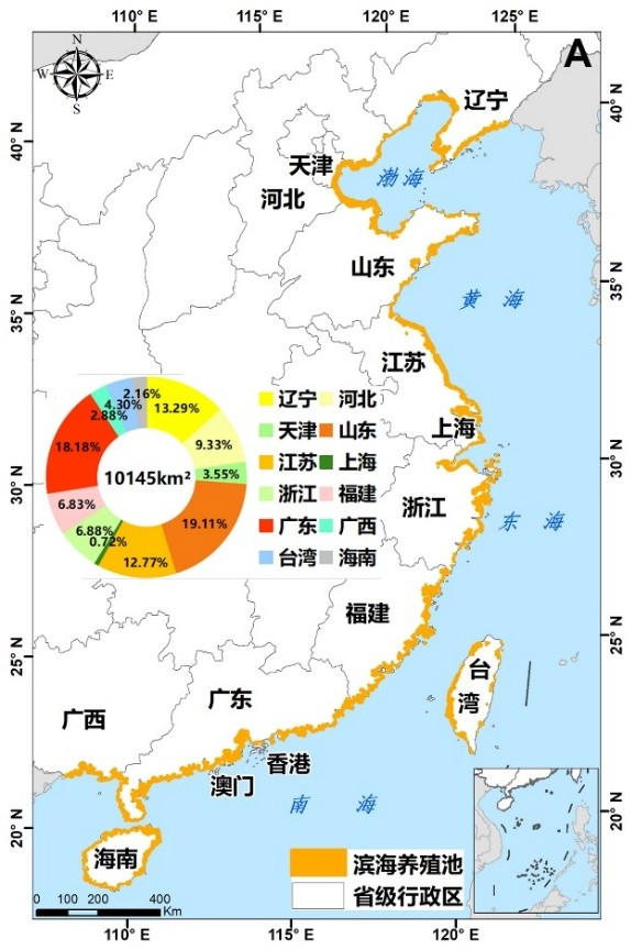
國互花米草空間分布(2015年) 中國濱海養(yǎng)殖池空間分布(2015年)
數(shù)據(jù)集由王宗明、毛德華、賈明明、任春穎等生產(chǎn)。在國家地球系統(tǒng)科學(xué)數(shù)據(jù)中心等網(wǎng)站注冊后,即可免費(fèi)下載使用。獲取地址如下:(1)國家地球系統(tǒng)科學(xué)數(shù)據(jù)中心:http://www.geodata.cn/thematicView/wetland2020.html;(2)國家地球系統(tǒng)科學(xué)數(shù)據(jù)中心黑土與濕地分中心:http://northeast.geodata.cn/special/user.html#content1;(3)中國科學(xué)院東北地理與農(nóng)業(yè)生態(tài)研究所科學(xué)數(shù)據(jù)中心:http://www.igadc.cn/wetlands/u54e0,http://www.igadc.cn/wetlands/u1fd8,http://www.igadc.cn/wetlands/u9647,http://www.igadc.cn/wetlands/u6c1f。
歡迎下載使用。聯(lián)系人:毛德華maodehua@iga.ac.cn、賈明明jiamingming@iga.ac.cn、任春穎renchy@iga.ac.cn、王宗明zongmingwang@iga.ac.cn。
上述數(shù)據(jù)集的關(guān)聯(lián)文獻(xiàn)如下:
[1] Mao, D.H., Wang, Z.M., Du, B.J., Li, L., Tian, Y.L., Zeng, Y., Song, K.S., Jiang, M., Wang, Y.Q. 2020. National wetland mapping in China: A new product resulting from object based and hierarchical classification of Landsat 8 OLI images. ISPRS Journal of Photogrammetry and Remote Sensing, 164: 11-25.
[2] Mao, D.H., Wang, Z.M., Wu, J.G., Wu, B.F., Zeng, Y., Song, K.S., Yi, K.P., Luo, L. 2018. China's wetlands loss to urban expansion. Land Degradation and Development, 29: 2644-2657.
[3] Mao, D.H., Luo, L., Wang, Z.M., Wilson, M.C., Zeng, Y., Wu, B.F., Wu, J.G. 2018. Conversions between natural wetlands and farmland in China: A multiscale geospatial analysis. Science of the Total Environment, 634: 550-560.
[4] Mao, D.H., Liu, M.Y., Wang, Z.M., Li, L., Man, W.D., Jia, M.M., Zhang, Y.Z. 2019. Rapid Invasion of Spartina alterni?ora in the Coastal Zone of Mainland China: Spatiotemporal Patterns and Human Prevention. Sensors, 19: 2308.
[5] Jia, M.M., Wang, Z.M., Wang, C., Mao, D.H., Zhang. Y.Z. 2019. A new vegetation index to detect periodically submerged mangrove forest using single-tide Sentinel-2 imagery. Remote Sensing, 11: 2043.
[6] Jia, M.M., Wang, Z.M., Zhang, Y.Z., Mao, D.H., Wang, C. 2018. Monitoring loss and recovery of mangrove forests during 42 years: The achievements of mangrove conservation in China. International Journal of Applied Earth Observation and Geoinformation, 73: 535-545.
[7] Jia, M.M., Wang, Z.M., Li, L., Song, K.S., Ren, C.Y., Liu, B., Mao, D.H. 2014. Mapping China’s mangroves based on an object-oriented classification of Landsat imagery. Wetlands, 34: 277-283.
[8] Liu, M.Y., Mao, D.H, Wang, Z.M. 2018. Rapid invasion of Spartina alterniflora in the coastal zone of mainland China: New observations from Landsat OLI images. Remote Sensing, 10 (12): 1933.
[9] Ren, C.Y., Wang, Z.M., Zhang, Y.Z., Zhang, B., Chen, L., Xi, Y.B. 2019. Rapid expansion of coastal aquaculture ponds in China from Landsat observations during 1984–2016. International Journal of Applied Earth Observation and Geoinformation, 82: 101902.
附件下載:

 吉公網(wǎng)安備22017302000214號